Home > Datasheets
Product Datasheets

GVERSE GeoGraphix
Product Overview
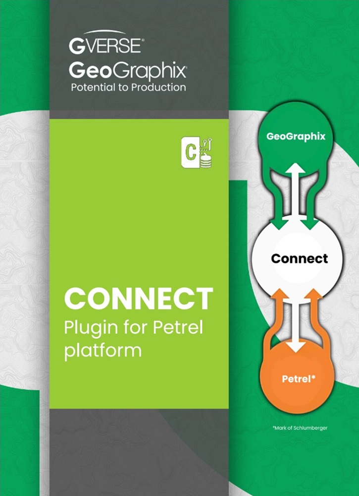
GVERSE GeoGraphix is the latest evolution in G&G software
that delivers advanced geological and geophysical interpretation at
an exceptional price. The latest release of GVERSE GeoGraphix
includes revamped geophysics, fast subsurface modeling and a
laser-like focus on the core workflows geoscientists use every
day.
Download the PDF and learn more

GeoGraphix® 2019.3
Release
GeoGraphix is a complete, affordable, geoscience system
offering leading edge mapping; geological, geophysical &
petrophysical modeling; well and field planning and,
state-of-the-art 3D visualization.
Download the PDF and learn more

GVERSE Geology
State of the art Geological interpretation tools for structure and stratigraphic analysis, mapping and geosteering.
Download the PDF and learn more

GVERSE Geophysics
Powerful, 2D and 3D seismic interpretation system for rapid prospect generation.
Download the PDF and learn more

GVERSE DATA
GVERSE Data includes well and production data, land grid, and
culture data in native GeoGraphix file formats.
Download the PDF and learn more

GVERSE Geophysics
2019.3
GVERSE Geophysics is a powerful new seismic interpretation
system that provides powerful 3D visualization capabilities. GVERSE
Geophysics enables geoscientists to execute end-to-end workflows
for basic interpretation and more advanced geophysical
workflows.
Download the PDF and learn more
GVERSE Geomodeling
2019.3
GVERSE Geomodeling offers an extensive integrated solution for
subsurface Geological/Reservoir Modeling. Detailed analysis of the
reservoir is always crucial prior to final consideration. With
GVERSE Geomodeling, making an informed decision is much easier as
this application supports numerous types of data sources for
comprehensive understanding of the petroleum system
components.
Download the PDF and learn more

GVERSE Petrophysics
2019.3
GVERSE® Petrophysics is a 64-bit petrophysical application
designed to assist geoscientists and petrophysicists in analyzing
and interpreting well log data and characterizing the reservoir
using advanced log interpretation workflows in a multi-well
multi-user environment.
Download the PDF and learn more
GVERSE FieldPlanner
2019.3
GVERSE FieldPlanner offers powerful field planning
capabilities that result in time and cost reductions, allowing
field planners to create, save, analyze, and manage multiple field
plan scenarios to determine optimal hydrocarbon production.
Download the PDF and learn more

GVERSE Planner
2019.3
GVERSE Planner allows multiple well planning to easily
visualize geologic surfaces, quickly create surveys and
geoprognosis reports, and just as easily make changes to existing
well plans.
Download the PDF and learn more
GVERSE Connect
2019.2
Seamlessly integrate well, seismic and maps to increase
efficiency in an integrated interpretation environment with GVERSE
Connect.
GVERSE Inversion
2017.3
GVERSE Inversion 2017.3 offers features enhancements to
deliver high resolution impedances ensuring your well is drilled
through the ideal reservoir. Completely integrated with LMKR's
GeoGraphix® suite of products, the GVERSE Inversion 2017.3 plug-in
provides a rapid, yet robust way to derive geological
details.
Download the PDF and learn more

GVERSE WebSteering
2017.3
The only web browser based geosteering application in the
industry that delivers optimal well placement with simple data
loading and full integration with GeoGraphix.
GVERSE Predict3D
2017.3
GVERSE Predict3D is a multi-attribute inversion solution*,
based on spectral decomposition and state-of-the-art optimization
techniques, to predict rock properties away from wells using well
logs and seismic data.
GVERSE Attributes
2017.3
GVERSE Attributes enables geoscientists to harness the full
power of seismic attributes by drastically reducing the time,
effort and disk space required for attribute analysis.

GVERSE GeoGraphix and Spotfire Integration
GVERSE GeoGraphix and TIBCO Spotfire integration allows seamless transfer of data between GeoGraphix and Spotfire. In the integrated workflow, GVERSE GeoGraphix serves as the data source for TIBCO Spotfire to perform data analysis, discovery, decision-making, and insights on the data stored in the GeoGraphix database.
Download the PDF and learn more

GeoAtlas
GeoAtlas is a GIS-based, mapping environment for geologic base
and subsurface mapping. Built on Esri ArcObjects technology,
GeoAtlas is used to create presentation-quality maps from a variety
of spatial data sources including shapefiles, web map services
(WMS), ArcGIS map services and SDE layer s.

IsoMap™
The LMKR GeoGraphix IsoMap utility is a comprehensive surface
modeling and contouring application that can be used on a wide
variety of data sets.Download the PDF and learn more

Discovery™
smartSECTION®
Discovery smartSECTION is part of the LMKR GeoGraphix Basic
Geologic Interpretation system that is composed of core
applications that the petroleum geologist needs to interpret and
map subsurface data.

LeaseMap®
LMKR LeaseMap software provides a complete understanding of
any region's mineral interest and leasehold situation.

LogM Seismic Modeling
Software
The LogM™ modeling package is an add-on to the Advanced
Synthetic Package and includes industry-standard stratigraphic
modeling and structural modeling.

LogM™ Advanced
Synthetics Software
LogM™ advanced synthetics software is the industry standard for
seismic synthetic generation. It provides geoscientists with all
the tools necessary to accurately tie well control to seismic
data.
Geomodeling While
Drilling in Discovery smartSTRAT
As a result of the increase in horizontal well drilling and
new 'factory production' development methodologies, geoscientists
are being asked to plan and drill more wells simultaneously, in
less time and with greater accuracy.

Value Added Services
Manage your data growth to ensure project stability, maximize performance, and avoid loss of data and information.
Download the PDF and learn more

Information
Management
We make your complex digital oilfield data and information
complete; transparent; auditable; and, secure. Transforming it into
actionable knowledge which enables you to make critical decisions
to the everyday challenges your organization faces.
Download the PDF and learn more

Geoscience
Service
Make business critical decisions with the help of our
experienced geoscientists and engineering consultants.
Download the PDF and learn more